b29 under water
posted by pindec
just a quick post to note the floods; the river rea is all over the Selly Park playing fields, with water flowing from Kitchener Road onto them - when we took a look a few hours ago, water was geysering up in the middle through the manholes.
The Bournbrook broke its banks just by Pebble Mill and flooded 3rd, 4th and Sir John's Avenues, and the Pershore Road was flooded at Pebble Mill and Cartland Road.
Here's a video of the river at the bottom of First Avenue:
I took some more pictures, but not of the avenues flooding; I felt like it wasn't very helpful for the people whose houses were disappearing underwater to stand around and take pics of it ... but loads of people did have their cameraphones out so I'm sure there will be lots of pics.
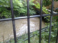
More floodwaters (apologies for the terrible camera angles):
Looks like it's stopped raining, so fingers crossed.
*UPDATE*
Sadly, the water kept rising - the bottom halves of Hobson and Kitchener Roads and Cecil road were really badly flooded, with water levels up to people's thighs. Fashoda Road was half flooded, and you couldn't drive up DogPool lane - there was a fire engine at the junction with Fashoda doing what it could.
The waters did start to subside around 5ish, but that was little consolation for the people whose houses were submerged. One of our neighbours reckoned it was by far the worst flooding for 20 years... and there's more rain forecast for Tuesday with the fallout of hurricane Gustav :(.
The Bournbrook broke its banks just by Pebble Mill and flooded 3rd, 4th and Sir John's Avenues, and the Pershore Road was flooded at Pebble Mill and Cartland Road.
Here's a video of the river at the bottom of First Avenue:
I took some more pictures, but not of the avenues flooding; I felt like it wasn't very helpful for the people whose houses were disappearing underwater to stand around and take pics of it ... but loads of people did have their cameraphones out so I'm sure there will be lots of pics.
More floodwaters (apologies for the terrible camera angles):
Looks like it's stopped raining, so fingers crossed.
*UPDATE*
The waters did start to subside around 5ish, but that was little consolation for the people whose houses were submerged. One of our neighbours reckoned it was by far the worst flooding for 20 years... and there's more rain forecast for Tuesday with the fallout of hurricane Gustav :(.
Labels: b29, flooding, floods, selly park

 B29 Links


3 Comments:
At 8:50 am, September 07, 2008 , Anonymous said...
How's Oakfield Rd. doing? We miss our old house there...
At 9:05 am, September 07, 2008 , pindec said...
hi robert - oakfield road was fine - just the very corner on the junction with pershore road was a bit soupy.
At 2:48 pm, September 09, 2008 , Anonymous said...
Hello pindec. I work for the Environment Agency and saw the extent of the damage for myself yesterday. I spoke to several residents who described what happened, and I'd be really grateful if you could send me any info: photos, personal accounts, maps etc so we can look into preventing this from happening again. Feel free to email me at: mappingmidcentral@environment-agency.gov.uk
Post a Comment
Subscribe to Post Comments [Atom]
<< Home